
Keyword
Earth Science | Biological Classification | Plants | Angiosperms (Flowering Plants) | Monocots | Seagrass
51 record(s)
Type of resources
Topics
Keywords
Contact for the resource
Provided by
Formats
Representation types
Update frequencies
Status
draft
-
This study collects information on intertidal seagrass meadows at Thursday and Horn Island, Torres Strait. Data is collected by scientists and trained students/ community volunteers using the standard Seagrass-Watch protocols (see www.seagrasswatch.org). Three permanently marked sites (50mx 50m) are monitored 3 - times a year. Data is submitted to Seagrass-Watch HQ for QAQC and submission to the main Seagrass-Watch MSAccess database (Northern Fisheries Centre, DPI&F custodians). Summary data and anaylis is presented in quarterly newsletters and available on the web as part of State of teh Environment reporting.
-
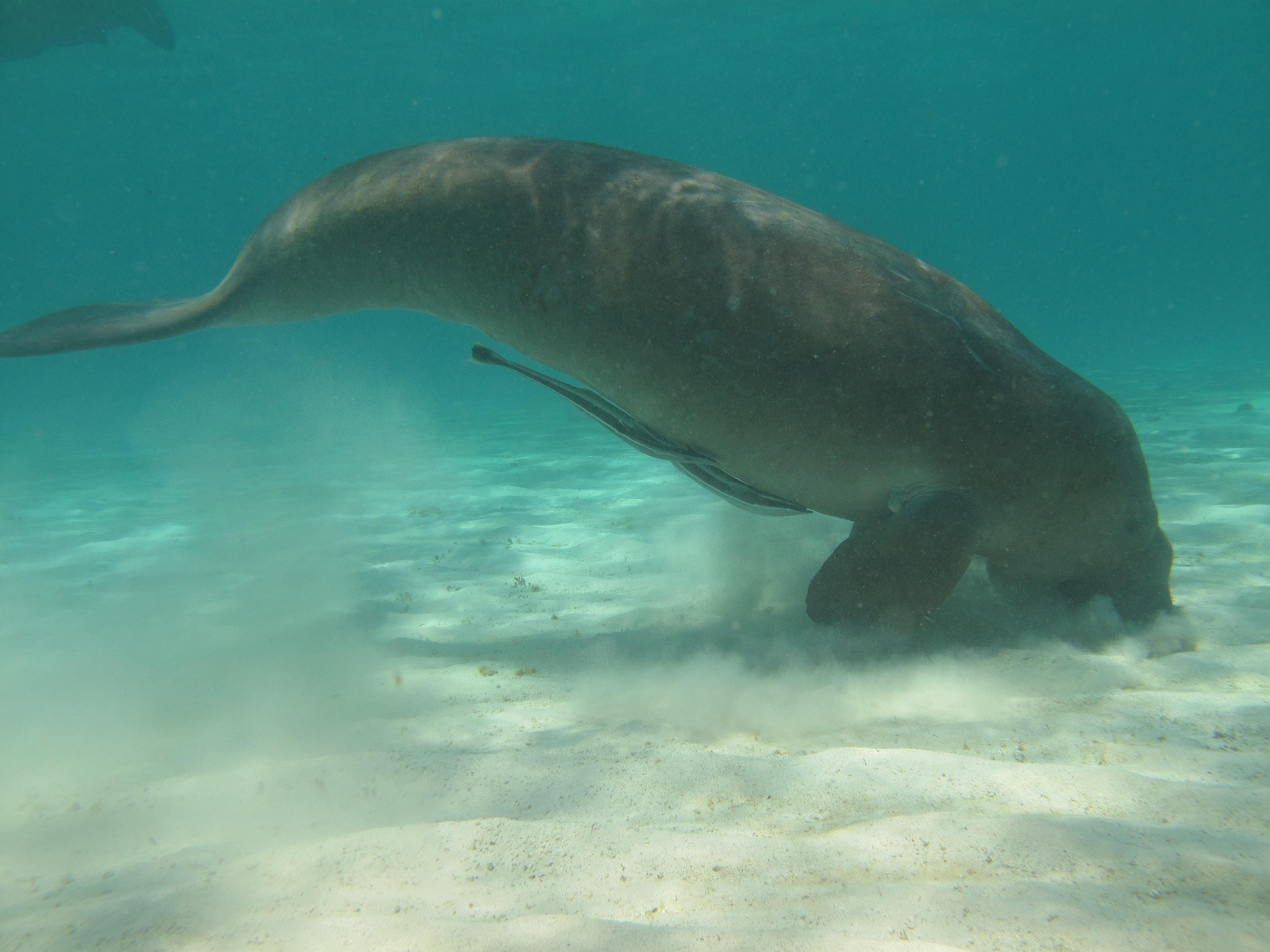
Dugongs (Dugong dugon) are listed as vulnerable on the IUCN Red List of Threatened species and as other specially protected fauna in WA under Schedule 7 of the Wildlife Conservation (Specially Protected Fauna) Notice 2015). Gaps in our knowledge in Western Australia include having a good understanding of the species’ distribution, abundance and high use areas across the northwest. This 3-year project (2014-2017) integrated Indigenous knowledge and scientific observations from field surveys to better understand the distribution, abundance and movements of dugong in the Kimberley region. The data collected also provides a baseline for future monitoring and management. This medata record relates to raw and processed aerial survey data of marine fauna collected between 21st September 2015 and 8th October 2015 in Kimberley coastal waters to the 20m bathymetry line, comprising dugongs (Dugong dugon), Australian snubfin dolphins (Orcaella heinsohni), other dolphins (bottlenose, spinners, false killer whales), humpback whales (Megaptera novaeangliae) and large, mostly green turtles (Chelonia mydas). The WA Department of Biodiversity Conservation and Attractions (DBCA, ex-DPaW) and CSIRO provided additional resources to extend the North Kimberley dugong aerial survey boundary westwards (Broome to just past Port Hedland) to cover the South Kimberley-Pilbara coastal regions, to close the last remaining knowledge gap of the dugong distribution and abundance in Australia. This additional survey was completed in May 2017. Data from a trial movement study undertaken between 1-18th August 2016 also forms part of this metadata record. Five dugongs were tagged with Telonics manatee/dugong tags. GPS and ARGOS satellite detection locations and dive data were downloaded weekly from the ARGOS web site.
-
The marine benthic habitats of seabed areas between the reefs of Torres Strait were classified with data collected on epibenthos abundance, seagrass presence or absence, substrate type and water depth from 1984 to 1989 at 984 sites in an 12,347 square km study area in central Torres Strait. An idex of habitat diversity, calculated as the variety of distinct habitats within a 10 x 10 km window passed over the study area indicated that the areas with highest diversity of habitats were among the reefs and islands that formed two bands; one from Cape York to Buru Island, and the other from Cape York to Daru Island that included the Warrior reef complex. Refer to the compiled report: Long BG and Taranto TJ. (1997) Habitat Classification Of Seabed Areas Of Torres Strait, Northern Australia. CSIRO Division of Marine Research, QLD, Australia.
-

As part of the Pilbara Marine Conservation Partnership (PMCP), coral reef surveys of reef macroalgae species (including seagrasses) were undertaken between northern Ningaloo and the Dampier Archipelago. This dataset contains biomass estimates (g DW m-2 and g WW m-2) of macrophytes collected in shallow reef areas in the Pilbara region during two sampling trips: November 2013 and May 2014. Surveys were undertaken using using SCUBA at depths between 2-13m, with macroalgae and seagrasses identified to the lowest possible taxonomic level. The data include: * Macroalgae and seagrass diversity (0.25 square metre quadrats) * Macroalgae and seagrass species composition and biomass per quadrat (0.25 square metre) These data were collected to estimate macrophyte biomass in shallow reef areas across the Pilbara region in two contrasting seasons. These data are an output of the Pilbara Marine Conservation Partnership (PMCP) Coral Reef Health Theme.
-
This dataset is a composition of various datasets to form a map at the 1:100000 scale of the seagrass and underwater habitats from Shark Bay to NSW border going south and including Tasmania. Data extends up to 50Km offshore. The dataset was compiled largely by Dr Hugh Kirkman and subsequently updated by Dr. Ian Hahmdorf, (Bureau of Rural Sciences) and became part of CAMRIS as the CAMRIS Seagrass Dataset. Additional details (including a link to download the data as shapefile) are accessible via the www.environment.gov.au website (see links section).
-
Coral reef surveys of reef macroalgae species (including seagrasses) were undertaken between northern Ningaloo and the Dampier Archipelago. This dataset contains biomass estimates (g DW m-2 and g WW m-2) of macrophytes collected in shallow reef areas in the Pilbara region during two sampling trips: November 2013 and May 2014. Surveys were undertaken using using SCUBA at depths between 2-13m, with macroalgae and seagrasses identified to the lowest possible taxonomic level. The data include: * Macroalgae and seagrass diversity (0.25 square metre quadrats) * Macroalgae and seagrass species composition and biomass per quadrat (0.25 square metre) These data were collected to estimate macrophyte biomass in shallow reef areas across the Pilbara region in two contrasting seasons.
-
Seagrass surveys were carried out between the Vanderlin Islands and Rosy Creek, Gulf of Carpentaria to investigate the impact of dredging by MacArthur River Mines. Data were collected on seagrass density, morphometrics, sediments, and environmental factors.
-
Measures of seagrass seed density were taken from sites around Groote Eylandt, Gulf of Carpentaria, in the 1980s, and from the Vanderlin Islands, Gulf of Carpentaria, in 1992.
-
This dataset contains seagrass distribution and density data from Marmion Lagoon, Perth, Western Australia. Every 6 months from 1979 until January 1998, two transects a north south and an east west (370 m and 330 m long) in 4 m of water were conducted. Any species or density changes along the transects were recorded.
-
Two mangrove sites and two seagrass sites were sampled in each region of the Gulf of Carpentaria; Weipa (between 1991 and 1994) and Groote Eylandt (between 1994 and 1995). The stable isotope ratios of seagrass, mangroves and prawns were measured, and the contribution of mangroves and seagrass to prawn food webs was estimated.